
Kaikōura quake shaped our understanding of complex earthquakes and preparedness: reflections on the tenth anniversary
Ten years after the magnitude 7.8 Kaikōura earthquake struck just after midnight on 14 November 2016, the event remains one of the most significant earthquakes in New Zealand's modern history.
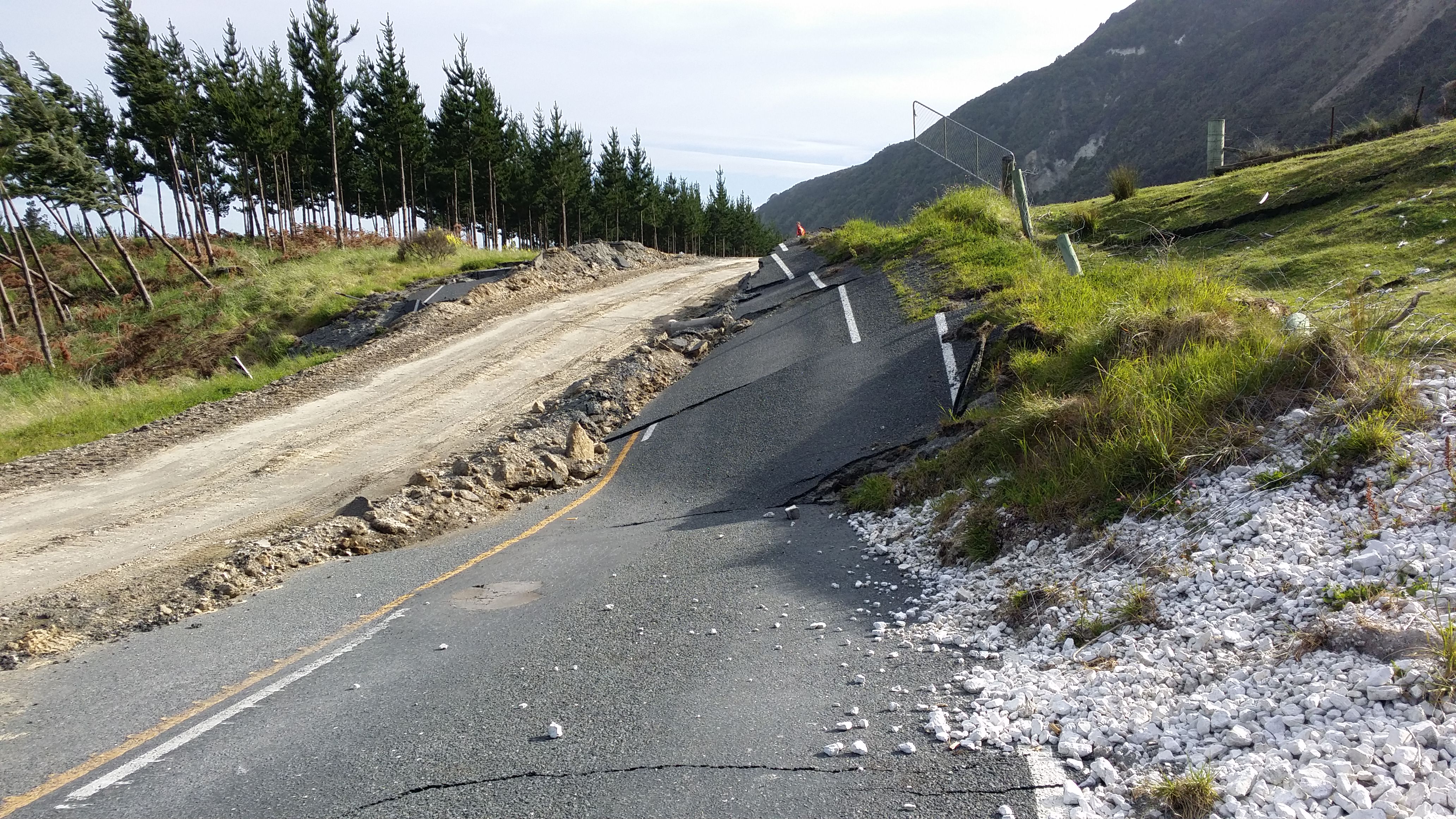
The earthquake claimed two lives, triggered tens of thousands of landslides, cut off communities, damaged critical infrastructure across the upper South Island and lower North Island, and generated a tsunami that reached parts of the New Zealand coastline within minutes. It was New Zealand's largest earthquake since the 2009 Dusky Sound event and one of the most scientifically important earthquakes ever recorded worldwide.
For New Zealand scientists, the Kaikōura earthquake was both a stark reminder of the country's place on the boundary between the Australian and Pacific tectonic plates and a catalyst for a decade of research that continues to shape our understanding of earthquake hazards.
"New Zealand sits in one of the most tectonically active regions on Earth," says Dr Anna Kaiser – Chief Scientist Earthquake Hazards at Earth Sciences New Zealand. "The Kaikōura earthquake showed us just how complex our earthquakes can be. Ten years on, we're still learning from it."
A rupture that rewrote the textbooks
What made the Kaikōura earthquake extraordinary was not only its size, but how it unfolded.
Rather than rupturing a single fault, the earthquake jumped across a network of faults over a distance of around 180 kilometres. Scientists later identified more than 20 faults that ruptured during the event, making it one of the most complex multi-fault earthquakes ever documented.
Before 2016, scientists knew the region contained numerous active faults. However, the extent to which these faults could rupture together in a single earthquake had not been fully appreciated.
The earthquake accelerated scientific investigations into how fault systems behave and demonstrated that large earthquakes can cascade through interconnected networks of faults in ways that are difficult to anticipate.
"The earthquake highlighted the diversity of ways faults can break and interact. Understanding that diversity and translating this into hazard forecasting remains one of the key scientific challenges we are working on today," says Dr Kaiser.
The findings have influenced earthquake research not only in New Zealand but internationally, with the event becoming a globally significant case study for understanding complex fault systems.
In time for the tenth anniversary, all of the faults that ruptured the ground surface are available to view in high-resolution on our Active Faults Database. The database web map displays active fault traces at or near the surface, as well as the fault names, sense of movement, displacement, recurrence interval and other parameters.
Hazards that extended far beyond the fault rupture
The earthquake's impacts were felt well beyond the faults that broke.
Strong and severe shaking was experienced in communities across northeastern South Island and Wellington. Shaking triggered more than 30,000 landslides across the affected region, reshaping hillsides, damming rivers and blocking transport corridors. State Highway 1 and the Main North Line railway were severed in hundreds of locations, leaving Kaikōura isolated for weeks.
The scale of landslide activity sparked major new research efforts, including the Sliding Lands Endeavour programme, which has improved understanding of landslide hazards and how they evolve following large earthquakes.
The earthquake also highlighted how large earthquakes can produce damage far from their epicentre. The earthquake began in North Canterbury and ruptured across many faults on its way to the Cook Strait.
The way the rupture unfolded meant energy was directed towards Wellington, where seismic waves were also amplified and trapped within Wellington’s sedimentary basin, causing damage in particular to taller or mid-rise structures in the city.
Our scientists had studied the Wellington Basin, understanding that its steep-sided 3D structure and soft sediments could lead to amplified shaking that could persist longer than many people expected. Since the earthquake, our collaborative studies have been delving into the block-by-block details of how the ground shakes, with the goal of providing more accurate models to inform our National Seismic Hazard Model and engineering design. Wellington is also just one of the many sedimentary basins in New Zealand where we can expect amplification effects.
Each earthquake is unique, producing its own ground shaking patterns that are influenced by the way the ground ruptures, the way waves travel through the Earth, and the local conditions. When we consider seismic hazard, we need to think about all possible earthquakes that could impact New Zealand.
Updating New Zealand's earthquake hazard models
Since the Kaikōura earthquake, the New Zealand National Seismic Hazard Model (NSHM) has undergone a major update across many of its components, incorporating advances in our understanding of earthquake occurrence, fault behaviour, and ground motions. Science emerging from the Kaikōura earthquake has played an important role in refining these models, particularly through insights into multi-fault rupture processes, complex fault interactions, and the cascading nature of large earthquakes.
“The Kaikōura quake reminded of us of the complexity and time-dependent nature of earthquakes. How frequently earthquakes occur is constantly changing, and improving our ability to model this time-dependence is where our next paradigm shift in forecasting future earthquake shaking is likely to come from,” says Dr Matt Gerstenberger – Earthquake Hazard Seismologist at Earth Sciences NZ.
The NSHM currently provides 100-year forecasts of ground shaking, which are the scientific foundation for many of the country's building standards, infrastructure planning decisions and risk assessments. A key next step is to develop 1-year forecasts so that the NSHM can capture aftershocks and other quake clusters.
"This earthquake highlighted that we need to continually test and update our science," says Dr Gerstenberger. "Every major earthquake provides new information, and incorporating that knowledge is essential if we want the most robust picture of future hazard."
Improving how New Zealand responds
The earthquake also drove significant changes in operational monitoring and emergency response.
In the hours after the event, our scientists worked around the clock to uncover what had happened, assess ongoing hazards and provide advice to emergency managers and government agencies. Multi-disciplinary science teams were activated, and scientists were deployed to support decision makers from emergency coordination centres, including at the Beehive.
The experience highlighted the need for enhanced real-time monitoring capability, particularly to support time-critical tsunami assessments.
One result was the establishment of the National Geohazards Monitoring Centre, which now provides 24/7 eyes-on monitoring of earthquakes, volcanoes, tsunami and landslides. The centre ensures that specialists are continuously watching New Zealand's geohazards and can rapidly assess emerging events.
The earthquake also accelerated research into rapid hazard detection and warning systems. Programmes such as Rapid Characterisation of Earthquakes and Tsunami (RCET) and its successor Next-Generation Early Warning (RCET-NEW) have been developing tools and expertise that enable faster and more accurate assessments of large earthquakes and their tsunami potential. This programme is also exploring the optimum science pathway for future earthquake early warning in New Zealand. The Sliding Lands programme is also developing rapid landslide forecasts and assessments.
The work is not finished
For Dr Kaiser, the anniversary is both a moment of reflection and a reminder of the work still ahead. “The Kaikōura earthquake really highlighted several big scientific challenges that scientists have been working towards solving.”
- What complexity and diversity of earthquakes could we really see in NZ?
- How often do these complex events occur?
- What are the implications of the quake for the future?
- How can we more accurately model and forecast local hazard and impacts?
- How can we provide faster and more accurate scientific information when large earthquakes, landslides, and tsunami occur?
“The Kaikōura earthquake has catalysed science in New Zealand, and we are making progress towards answering all the above questions. Continued research is critical to helping communities understand and prepare for future earthquakes."
A decade after it struck, the Kaikōura earthquake remains more than a historic event. It is a living scientific legacy, continuing to shape how New Zealand studies, monitors and prepares for the natural hazards that come with life on an active plate boundary.
On the tenth anniversary of the M7.8 Kaikōura earthquake, our thoughts are with the families of those who lost their lives, and whose lives were turned upside down on the night of the 14th of November 2016.
We have come such a long way as a country, but have a long way to go to get prepared for future earthquakes and other hazards. To learn more about how to get prepared, check out:
For other information about the Kaikōura quake anniversary, check out: